(This article appeared in December 1998 AAPG Explorer) By KAREN RAE CHRISTOPHERSON
Next month: What the data mean, and case histories. |
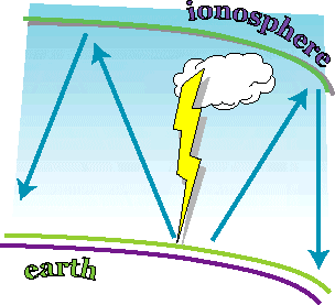
MT Gauges Earth's Electric FieldsMagnetotellurics. That's a big word -- longer than my last name! So, let's dispense with the big words for the rest of this article and use the abbreviation that most geophysicists know this technique by, that is, MT. This first part of a two-article series will deal with the MT technique -- what is it? Next month's article will explain the applicationof MT and show some case histories. First, back to the big word. Where does it comefrom? Dissected, it has two parts -- "magneto" for magnetic and "telluric" for earth currents. This tells you something about MT. It is a geophysical method that measures magnetic and electric fields that arefound in the earth. Basically, MT is a geophysical method that measures naturally occurring, time-varying magnetic and electric fields. From these measurements we can derive resistivity estimates of the subsurface, from the very near surface to tens of thousands of feet. What is the Source of the MT Signal?The MT signal is caused by two things:
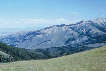
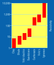
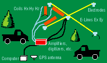
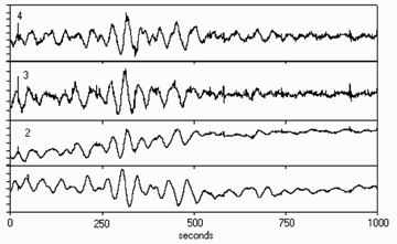
Both of these sources of signal create time-varyingelectromagnetic waves. Although these electric and magnetic fields are small, they are measurable. That's the good news. The bad news is that these signals vary in strength over hours, days, weeks and even over the sunspot cycle (which is about 11 years and creates an increase in the number of solar storms). So, geophysicists measuring MT have to measure for hours at each station in order to get enough signal to ensure high quality data. This is especially true when measuring them at the lowest frequencies (about 0.001 Hertz, or 1 cycle per 1000 seconds). At these low frequencies, we need to record for 16 minutes to get one sample of data! That means we really need to record for several hours just to get a decent statistical average of good data. What is MT used for? The MT method itself has only been in existence since the 1960s. Practical systems came into use in the 1970s, with large improvements made in the 1980s. The last two or three years have seen the advent of smaller systems, taking advantage of GPS and faster computers, as well as 24 bit A to D conversion (more on that later). At first, MT was used mostly for reconnaissance mapping of basins and geothermal prospects. In the 1980s, MT came into use for petroleum exploration, mainly in frontier areas. This is because MT is very portable (a station can be placed almost anywhere with access by horse, helicopter, snowmobile, etc.) and because MT works best where seismic has problems, i.e. areas of high-velocity cover such as volcanic provinces, overthrusts, carbonate cover or salt. These days, MT can be used in frontier areas where seismic acquisition is difficult or prohibitive (due to cost or environmental factors) to map prospects (usually structural). The data are normally integrated with whatever other information is available (gravity, magnetics, geology, and borehole). MT can be used in lieu of seismic in areas where seismic acquisition is not possible. MT can be applied in lead of seismic (to help determine the best placement of seismic lines). And MT can be acquired in conjunction with seismic, in order to have a "second" opinion of subsurface structure or stratigraphy. What Can MT Tell Us About the Subsurface?The main parameter that is derived from MT is resistivity. The main factor affecting resistivity is lithology -- however, other parameters can come into play as well (such as pore fluid, pressure, and temperature). Figure 4 shows how resistivity can vary with lithology. Resistivity is given in ohm-meters. Note that the main contrasts are between the volcanic/igneous/carbonate groups versus the clastics under a higher resistivity material, but can be used to map sands versus shales -- it all depends on the actual resistivity contrast between the units and the thickness of the units. The deeper the unit is, the thicker it has to be in order to be mappable by MT. MT data can be interpreted to give an estimate of resistivity variations with depth. This is normally displayed as a cross-section, where formations or units of differing resistivity are mapped in the subsurface. Since MT needs a resistivity contrast to be present in order to map a boundary, and since these units need to be fairly thick to be mapped, the sections will not have the resolution of seismic sections. How Are MT Data Acquired?An MT crew will normally acquire between two and six stations at the same time. Each station is independent of the others. One MT station consists of a set-up as shown in Figure 5. The stations can be anywhere from 1/4 mile to tens of miles apart, depending on the type of survey -- is it reconnaissanceor detail (prospect high-grade)? At each MT station, five measurements (channels) are recorded. They are the magnetic field in two horizontal directions and in the vertical direction, and the electric field in two horizontaldirections. The horizontal measurements are at 90-degree angles to each other (e.g. north and east) and as close to level as possible. The vertical electric field is not measured because it is assumed to be zero. The directions are labeled as x, y and z, with z being the vertical direction. The electric field is abbreviated "E" and the magnetic field is abbreviated "H." Hence, we measure Ex, Ey, Hx, Hy and Hz. And, 10 to 30 channels are recorded at one time. More channels could be recorded, but this is usually limited by logistics. The magnetic fields are measured with a type of magnetometer, basically an iron-cored coil with thousands of turns of wire. These coils are encased in waterproof containers, like PVC, and have a cable extending from one end. The coils are extremely sensitive to noise from wind, walking or trucks, and are buried in soil or under rocks to preventmovement. The electric fields are measured with long "antennae," or dipoles -- usually wires about 300-500 feet long. The ends of the wires are connected to "pots" -- sealed containers a few inches in diameter and about six inches high. The pots have a porous ceramic base and are filled with an electrolyte solution (like silver/silver-chloride). These pots are buried a few inches in the ground and measure the voltage drop along the dipole length. The wires are susceptible to wind noise, so they are usually placed directly on the ground. The coils and electric-field dipoles are all connected to "sensor" boxes where filtering and amplification of the signals take place. Remember, these are very small signals we are measuring. The data then are sent to a laptop computer where they are digitized and recorded on digital media. This is where the new 24-bit A to D systems come in. These new systems allow for a much larger amount of data (in amplitude) to be transferred from analog to digital (A to D) signal, meaning that we can get more information out of the data and have more to work with when processing. The older systems were 16-bit A to D -- now we can record 156 times more information than a few years ago. The electric and magnetic fields are being measured as a function of time. An example of a time-series record is shown in Figure 6. Notice how the signals coincide with each other. The four channels are from top: Ex, Ey, Hx, Hy. Remembering basic physics, the electric field in the x direction (Ex) should correlate with the magnetic field in the y direction (Hy), and similarly Ey correlates with Hx. Hz (not shown) is recorded only to give us some information about the geologic strike. We will use Ex, Hy, Ey and Hx to tell us about subsurface resistivity. The data are synchronized with GPS signals. This is important, because as we record two or more stations at one time these data are compared with each other for noise. This method, known as "remote referencing," allows the data at one station to be compared to data at another station, recorded at exactly the same time, and compared for coherency. Any non-coherent data are thrown out and considered as noise. This greatly improves data quality. Recording at each station takes 6-18 hours, depending on signal strength and survey parameters. Editor's note: Christopherson has a BS in geologyand an MS in geophysics. She has over 22 years experience using MT, working for the U.S. Geological Survey, BP (Sohio) and has been president of Chinook Geoconsulting in Evergreen, Colo., for the past 10 years. Her e-mail is chinookgeo@aol.com. |